 To the Dakota, the only waterfall on
the Mississippi and its surroundings is known as Owamni Yomni
(Whirlpool), revered for centuries as a place of tremendous spiritual
power and inspiration. Wita Waste (Beautiful Island) the key above
the falls, once covered in maple trees, was the site of annual
sugaring camps. The island below, Wita Wanagi (Spirit Island)
shrouded in mist and the peaceful din of rushing water, was a calm
and sheltered place where women gave birth to generations of Dakota
children. The people shared the area with a large population of
Eagles, for whom the waters provided a plentiful source of fish.
A rich oral tradition informs the
Dakota understanding of Owmani Yomni. One of these stories was first
written down in 1908 by historian Henry G. Allanson, whose records
remain in the collections of the Minnesota Historical Society.
He wrote, “Legend states that Anputa
Sapa Win, commonly known as Clouded Day, was the first and devoted
wife of a Dakota warrior. However, in time in accordance with the
custom, the husband introduced a second wife within the tipi. One day
the band camped near the falls of St. Anthony. Clasping her little
son, Clouded Day entered a canoe, pushed out into the swift current
chanting her death song. The Dakotas say that in the mists of
morning, the spirit of the Indian wife with a child clinging around
her neck is seen darting in a canoe through the spray, and the sound
of her death song is heard again in the winds and roar of the waters.
In seeming remembrance, a bear and her cub occasionally appear coming
out of the water.”
As the only portage on the river,
Owamni Yomni was a practical place for people of many nations to
gather, meet, rest, and trade. Even during times of turmoil between
the Dakota and Anishinabe, it remained neutral territory.
Owamni Yomni served as a natural
obstacle to human movement on the river and did the same for the
myriad species of fish, plants and aquatic mammals that lived in its
waters. Distinct ecosystems flourished above and below the falls,
protected from the potentially devastating effects of organisms whose
introduction might offset the delicate balance of each natural
sector.
So impressive was this feature of the
river – a horseshoe cascade that some European travelers compared
in grandeur to Niagara Falls – that the Dakota named the entire
2,552-mile waterway Haha Wakpa (Waterfall River) in its honor.
From those times forward, the
governments of France, the United States, Minnesota and Minneapolis,
along with their partners in industry and organized religion
conspired to makeover the sacred falls of Owamni Yomni,and many other
immovable landmarks, in their own image.
American history books claim Owamni
Yomni was discovered in 1680 by Father Louis Hennepin, a Franciscan
Friar who had been dispatched to explore the western part of “New
France,” an area which, at its peak in 1712, extended from
Newfoundland to the Rocky Mountains, and from Hudson Bay to the Gulf
of Mexico.
It is clear from Hennepin’s written
accounts of that journey that the priest considered himself the first
man to bear witness to both Niagara Falls and Owamni Yomni; in 1683,
he published a book about Niagara Falls called “A New Discovery.”
The Frenchman, upon arrival in Mni
Sota Makoce (Dakota Homelands) wasted no time imposing his vision on
the area’s natural features. He renamed Owamni Yomni “The Falls
of Saint Anthony,” after Anthony of Padua, the patron saint of
finding lost things and people. Why Father Hennepin chose Anthony of
Padua – a man who lived and died in Europe (1195-1231) – as the
new namesake for Owamni Yomni is shrouded in the mists of time.
Hennepin was first to record a written
account of Dakota interaction with the falls. His descriptions, while
colorful, bear no resemblance to the oral history or other historical
records. Whether Hennepin had a translator available proficient in
both French and Dakota in those nascent days of intercultural contact
is doubtful. Rather, like the missionaries of his time, and those who
would follow over the next three centuries, Hennepin’s written
observations of the Natives seem to reflect his own biases toward a
people he had prejudged as savage and heathen.
He wrote in his Description of
Louisiana (published in 1683), that one of the Dakota men in his
party chanted the following prayer while observing the powerful
waters: “You, who are a spirit…destroy our enemies, and bring
here captives, some of whom we will sacrifice to you.”
In the years that followed Hennepin’s
visit, a series of white explorers, missionaries, business tycoons
and politicians came through the area and – following Hennepin’s
lead, renamed sacred sites to reflect their claims to the area and
erase the memory of the Dakota’s special relationship to the land
and water.
Mde Maka Ska (“White Earth Lake”)
became Lake Calhoun; Wita Tanka (Big Island, near present day Fort
Snelling), the site of a Dakota creation story, became Pike Island;
Kaposia (Swift of Foot, Little Crow’s Village) became South Saint
Paul; and Oheyawahe (A Hill Much Visited), a long standing Dakota
burial site above the confluence of the Minnesota and Mississippi
Rivers, became Pilot Knob.
When European settlers began arriving
in Mni Sota Makoce following the completion of Fort Snelling in 1825,
they were naturally drawn to the magnificent waterfall on the
Mississippi, where – like so many people before them – they found
inspiration and power.
The outsiders established homesteads
around Owamni Yomni, an influx of migrants which would eventually
result in the establishment of a new city and the name of which, was
derived from the Dakota word for water (mni) and the Greek word for
city (polis). The invasion also resulted in the displacement of the
Dakota following the treaties of 1805, 1837 and 1851, which ceded
almost all Dakota land within the Minnesota Territory to the United
States and forced the indigenous population onto a small tract along
the Minnesota River.
The settlers renamed Wita Waste, the
island above St. Anthony Falls, Nicollet Island after the French
cartographer Joseph Nicollet, who traveled throughout the Dakota
Homelands during the 1830s. And Wita Wanagi, the Hemlock and Spruce
covered island below the falls, while never renamed, was translated
into English and called Spirit Island for the remainder of its
limited existence.
In the 1860s, industrialists who
coveted Saint Anthony Falls’ massive hydropower produced by the
gushing waters dug channel after channel into the rocky escarpment in
order to divert the cascading waters through their milling
facilities. Tourists began shying away from the falls. Those who
arrived in Minnesota Territory hoping to see something akin to
Hennepin’s majestic descriptions went away sorely disappointed, as
industrial pollution from the mills had spoiled the waters and shores
of Saint Anthony Falls.
 When Minneapolis was established in
1867 it was, perhaps, the last time Dakota stewardship of Owamni
Yomni was acknowledged by the now-dominant European population. This
acknowledgement was a final nod to the Dakota who, four years
earlier, following the US-Dakota War, were forcibly removed from Mni
Sota Makoce, and sent to the Crow Creek prisoner-of-war camp along
the Missouri River in Dakota Territory. (Today, Crow Creek is
classified as a reservation, and is consistently one of the five most
impoverished places in the United States, boasting a per capita
income of just over $4000).
Meanwhile, a handful of business leaders
built fortunes appropriating the natural resources of
the vacated Dakota lands. Many of those resources were conveyed on
the Mississippi to Minneapolis, where they were processed into
consumer and industrial products in the mills and factories along
Saint Anthony Falls. These goods were hauled off to markets on the
coasts on rails build by James J. Hill, who had been granted millions
of acres of Indian land to build his transcontinental Great Northern
Railway.
Some of the most recognizable names in
American industry made their vast wealth exploiting Minnesota lands
and waters during this era: Cargill Incorporated, which today is the
largest privately held American company, was founded by W.W. Gargill
in 1865; General Mills was founded by Cadwallader Washburn and James
Ford Bell in 1866; Pillsbury Company, whose historic mills along
Saint Anthony Falls are currently being converted into artists’
lofts, was started by Charles Alfred Pillsbury in 1872.
It was these very men whose
malfeasance and greed ultimately destroyed Saint Anthony Falls. On
October 5, 1876, the falls began breaking apart as the river crashed
through the top of one of the mills’ water diversion tunnels. The
falls were in danger of total collapse, and with them would go all of
the region’s water power. Hundreds of men volunteered to help fill
the gaping hole in the rock wall. Work continued day and night for
weeks to construct dams to divert water from the area. The efforts
stabilized the falls but would not provide a long-term solution.
Eventually, the United States Army
Corps of Engineers intervened. The Corps built a protective apron,
robbing the site of its original character, before the falls were
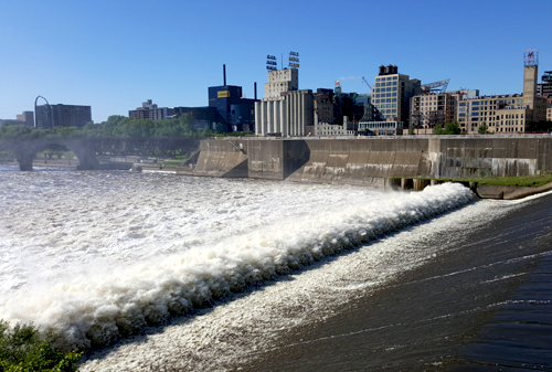
fully stabilized. What was once—under Dakota stewardship—one of
the most impressive natural sites on the continent, had been reduced
by business interests in a handful of years to an industrial concrete
waterslide.
The very bounty which made Minnesota’s
oligarchs wealthy destroyed what was left of Owamni Yomni’s. In the
1880s, millions of mill-bound logs—clear-cut from Minnesota’s
northern forests—tumbled over Saint Anthony Falls and hacked away
at Spirit Island’s rocky edges. The quarrying of limestone to build
saw and flour mills along the banks of the falls further reduced the
island’s height and length.
Once the preferred birthing place of
Dakota women, Spirit Island’s fate was sealed in 1960 when it was
removed by the Corps of Engineers to make way for the two new Saint
Anthony Falls navigation locks. Minneapolis officials wanted to spur
economic development in the city, and claim bragging rights to being
the uppermost port city on the Mississippi. With the removal of
Spirit Island, the desecration of Yomni Owamni was nearly complete.
One month before the first barge came
through the lock, Life magazine denounced the project as a “glaring
example of pork.”
In 1963, Upper Saint Anthony Lock,
which could carry two barges at a time over Saint Anthony Falls,
opened its gates to river traffic for the first time. Millions of
dollars had been spent, and much of the natural beauty of the area
sacrificed. As Life magazine had predicted, the prestige, and
financial boom of which city fathers had dreamed never came to
fruition as only a small handful of river shipping operations ever
opened in above the locks. Because the Upper Saint Anthony Falls Lock
could carry only two barges at a time—when other locks on the
Mississippi could handle nine—those who opposed the Lock’s
construction predicted from the outset that the vision of Minneapolis
as a port city was doomed.
Dakota spiritual people predicted the
development’s eventual downfall for other reasons.
Lakota chief Arvol Looking Horse has
noted the tendency of humans to settle and develop societies in
powerful places, such as Minneapolis/St. Paul (the conjunction of the
Minnesota and Mississippi Rivers, known in Dakota as Bdote), which
Looking Horse considers a “spiritual vortex.” Reflecting on that
notion in a 2003 interview with Bruce White and Bob Brown, the late
Prairie Island Dakota spiritual leader Chris Leith warned that people
should leave spiritual places alone. In the long run, he said, the
places would not be harmed or lose their spiritual power, rather, the
nature of the place would harm what was built there.
Some familiar with Leith’s assertion
pointed to his words four years later when, on August 1, 2007, the
35W Bridge collapsed into the Mississippi River—just downstream
from St. Anthony Falls, killing 13 people and injuring 145. The
bridge was Minnesota’s second busiest, carrying 140,000 vehicles
daily. The National Transportation Safety Board cited a
design flaw as the likely cause of the collapse, noting that
thin gusset plates ripped along a line of rivets, and
asserted that additional weight on the bridge at the time of the
collapse contributed to the catastrophic failure.
The 35W Bridge was quickly rebuilt at
the same location as the original, but another prominent structure
built on Owamni Yomni met its permanent demise last month. On June
15, the Upper Saint Anthony Falls Lock was closed by congressional
order. The closure was intended to stop the spread of Invasive Carp.
Also known as Asian Carp, these large, plankton-feeding fish are
moving northward in the Mississippi River, and pose a threat to
Minnesota’s rivers and lakes. While no breeding populations have
been detected in Minnesota’s Mississippi waters, individual fish
have been caught near the Twin Cities, and in the St. Croix River.
The carp are known to destroy aquatic ecosystems by overfeeding on
indigenous species. They can weigh up to 110 pounds and jump when
spooked by approaching watercraft. Boaters have been seriously
injured when struck by the fish at high speeds.
By closing the Upper Saint Anthony
Falls Lock, Congress has acted to return Owamni Yomni to function as
it had for centuries, as a divide between the upper and lower
Mississippi River’s unique natural systems. At least one important
food supply to Minnesota’s Native population will now be protected
from invasive carp: 90% of Minnesota’s wild rice grows north of
Saint Anthony falls within the Mississippi watershed.
After three centuries of destruction,
and the remaking the Dakota homelands in their own image, it appears
efforts are underway by the non-Indian population to repair at least
some of the damage. The closing of the Upper Saint Anthony Lock is
just one step in that direction.
There are proposals floating among
community groups within the halls of government to rename prominent
landmarks to reflect the way Dakota people have long understood them.
The Rum River, which runs from Lac Mille Lacs (Mde Wakan, Holy Lake)
to Anoka (The Village on Both Sides), could once again bear the name
Wakpa Wakan (Holy River); and Lake Calhoun in South Minneapolis—named
for the 7th vice-president of the United States, John C.
Calhoun, a South Carolina slave owner who ordered government
surveyors into the area around 1820, but who has no other ties to the
region—could once again be called by its Dakota name: Mde Maka Ska.
Perhaps the most exciting possibility
under discussion is a proposal to remove all three lock-and-dams that
control the water running through the Mississippi Gorge in the Twin
Cities. Just 30 feet beneath the surface of the lethargic Mississippi
lie the structure of a whitewater rapids that once roared over
immense boulders, around rocky islands and through the great river’s
only gorge on its way from Owamni Yomni to the Minnesota-Mississippi
River Bdote eight miles away.
Imagine the healing effects of the
rushing waters as they burst from behind their confinements, scouring
the long-buried banks and beds of the natural river, cleansing
everything in their path, obliterating a long history of malfeasance
and disregard for the Dakota, and for the sacred systems upon which
they relied.


